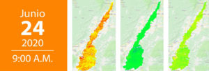
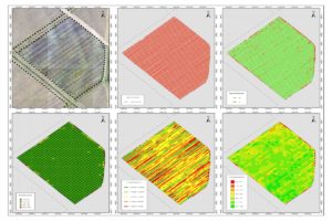
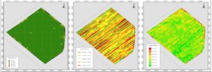
During the Webinar, we will talk about: Introduction to Image Processing. Derivative products with images obtained with UAVs. Project: Lines of Furrowing and Depopulation with images. images for monitoring vegetation. Go to registration page
During the Webinar, we will talk about: Introgression of resistance genes to Phythopthora capsici from wild Capsicum germplasm in commercial varieties of chili peppers to obtain resistant varieties of chili peppers. This event is organized by the Colombian Association of Phytopathology […]
During the Webinar, we will talk about: Images for monitoring vegetation.
During the Webinar, we will talk about: Introduction to Image Processing. Derivative products with images obtained with UAV. Project: Furrowing and Depopulation Lines with images Go to registration page Presenter Michael Andrés Arredondo. Topographic Engineer, Remote Sensing Analyst. Program of […]
During the Webinar, we will talk about: Introduction to Image Processing. Derivative products with images obtained with UAV. Project: Furrowing and Depopulation Lines with images
During the Webinar, we will talk about: Images for monitoring vegetation. Go to registration page Presenter Mario Andres Soto Valencia. Topographic Engineer, Remote perception analyst. Agronomy program, Cenicaña
On March 31, directors and researchers from the multinational Fraunhofer visited Cenicaña with the aim of establishing collaborative projects between both institutions.
The potential for the application of remote sensing in the agricultural world and particularly in the Colombian sugar agroindustry begins with the exploration of the utilities of the sensors available to obtain representative images of the terrestrial space, in this case […]
Remote sensing, also known as remote sensing or remote sensing, is the science of acquiring, processing and interpreting images and / or data, captured from aircraft or satellites, which record the interaction between matter (sugar cane) and radiation […]