The Site Specific Agriculture (AEPS) approach in the cultivation of sugarcane is intended to increase the efficiency of input use and improve the profitability of agribusiness.
In order for this crop management approach to fulfill its objective, it is essential to have soil mapping that facilitates its implementation. Today, in the agro-productive areas of the Cauca River Valley, there is a 1: 10,000 scale soil mapping, but the scope of AEPS could be much greater than having cartography at scales greater than 1: 1000.
Conventional methods of soil mapping to increase their information scale are often expensive, slow and tedious. Therefore, it is necessary to validate emerging technologies that allow optimizing the acquisition of soil information at multiple scales.
Mobile sensors of apparent electrical conductivity (CEa)
CEa mobile measurement sensors are an emerging technology suitable for generating soil mapping on an agricultural lot scale quickly, accurately and economically.
The magnitude of CEa values is determined by properties such as salinity, texture, organic matter and cation exchange capacity.
Currently, Cenicaña evaluates two CEa mobile sensors:
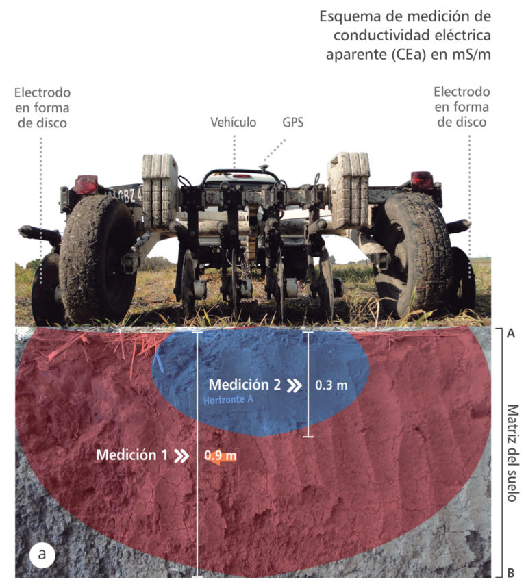
Veris Q2800® (Veris Technologies, Salina, KS) (Figure 1). It uses six disk-shaped electrodes to measure CEa. In addition, it allows georeference measurements every second at 0-0.3 m and 0-0.9 m depth. Its design allows to be pulled with a tractor.
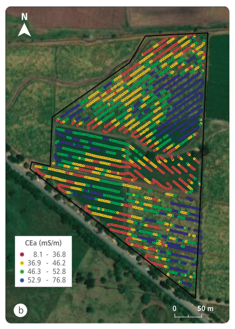
Veris Q2800® has been used to delimit soil-specific areas in various agricultural regions of the world. GSSI Profiler EMP-400® (Geophysical Survey Systems, Inc., Salem, NH) (Figure 2).
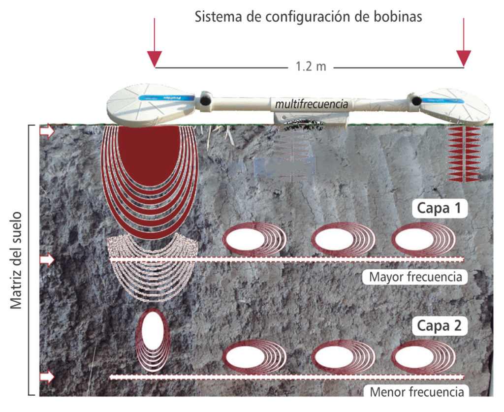
It measures CEa from multi-frequency electromagnetic induction. It is designed to be pulled manually or by vehicle. The measurement is recorded on a GPS device with a communication port connected to the device. The frequency range used is from 1 to 16 KHz. It is estimated that at 16 KHz frequency, this equipment measures CEa at a depth of ~ 0,7m.
Figure 1. Veris Q2800® sensor. to. Sensor components and functional description.
Figure 1. Veris Q2800® sensor. b. Spatial distribution of measurements (milliSiemens per meter [mS / m]).
Simultaneous measurement platforms
The simultaneous use of the two types of sensors allows the CEa to be measured at multiple depths. In this regard, Cenicaña validates a platform that increases the measurement efficiency of CEa and complements it with altimetry measurements. These variables can explain complex spatial patterns of the soil within the lots, which is ideal for the conditions of the Cauca river valley.
The speed and measurement distance of these platforms are currently validated, the results of which suggest that the range of density of CEa measurements can range from 1100 to 200 ha-1 measurements, with speeds of 5 and 25 km h-1, respectively. In addition, it was determined that 15-20 km h-1 is the appropriate speed to measure CEa with the platform.
A distance less than 9 m between measurement transects is ideal for determining the spatial patterns of the soil within the agricultural lots.
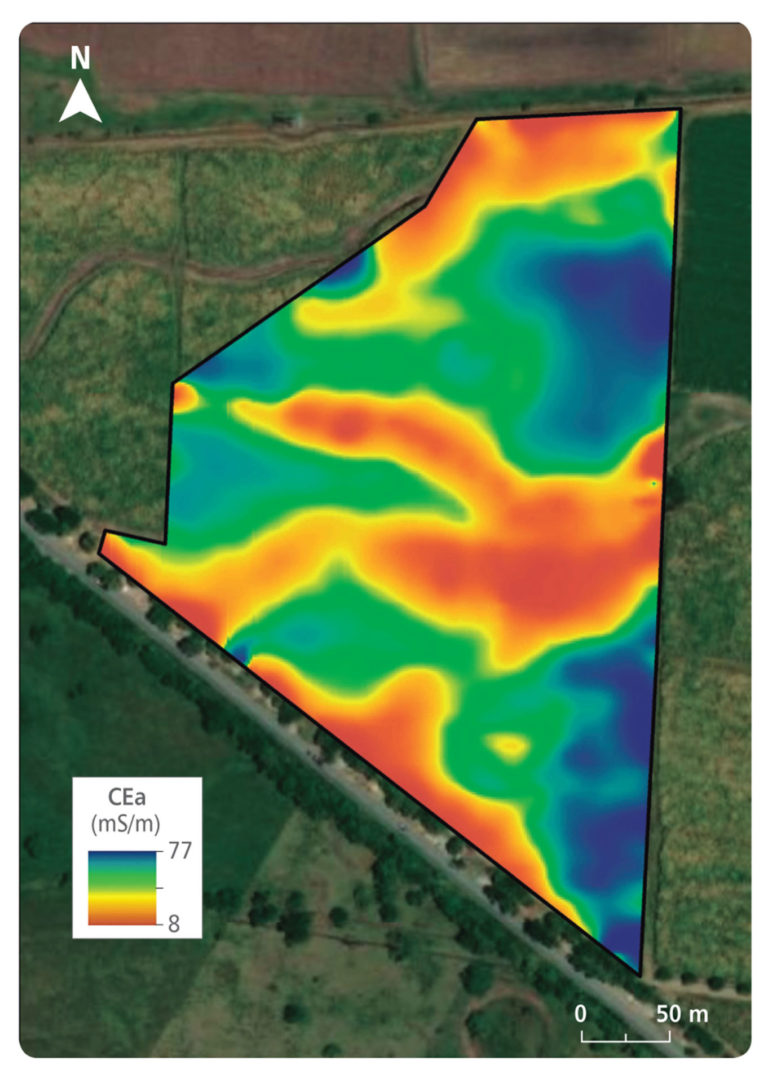
In an applied case, Figure 3 shows the spatial patterns of CEa in a batch of ~ 5 ha, at Ingenio Incauca. As can be seen, there is a considerable contrast in soil texture, which could be differentiated in detail using the aforementioned sensors. Low CEa values indicate considerable sand content and vice versa.
In other lots it has been possible to delimit areas by salt content. In addition, it is expected to delimit areas by content of organic matter or cation exchange capacity.
In addition, Cenicaña validates techniques to delimit soil-specific zones from CEa. The purpose is to implement fertilizer management and irrigation by soil-specific area. Likewise, model-based sampling schemes are being validated, in such a way that they identify the quantity and convenient location of sampling points.
Figure 2. Functional scheme of the GSSI Profiler EMP-400® sensor.
Figure 3. Spatial distribution of apparent electrical conductivity in commercial lot.
Site Specific Agriculture Researcher, Dr.Sc., Agronomy Program. mcastro@cenicana.org